Recent work culminated in a Design Charette sponsored by Washington Chapter of the American Society of Landscape Architects WASL, the National Park Service, Spokane City Parks and the local leadership group: The Inland Northwest Trails and Conservation Coalition & Nicoterra Trails. Below is the writeup on the website: a concept 9-mile trail connection through the valley (was studied). A trail connection in this area has been envisioned for many years. The study explores nature trail opportunities, combined with habitat conservation opportunities and storytelling of the natural/cultural history in Latah Valley Hangman Creek. It also explores water access points, trailhead locations, on-street routes, connections to existing parks and trail systems, and user experience. The study is an important resource document for ongoing park and open space planning efforts. Please note, some portions of the concept trail were proposed across private land, but these lands are indeed private and are not open to public use; please be mindful to avoid trespassing while exploring this area.including Nicoterra Trails. The designs of the various teams were then complied into a Latah-Hangman Trail Concepts and made available on the City’s website.
for implementation and design-build – –
Nicoterra Trails strongly urges the following steps:
- a Feasibility analysis of the methods for trail and restoration construction among alternatives presented in the report, from a wide (4′-6′) compact gravel trail proposed by some teams versus a narrow 2′ trail built lightly on the land with hand tools consistent with a USFS primitive trail standard. The latter standard was central to the development work of the local leadership group during three years of work. Building a primitve trail enables less damage to the sensitive ecology and affords better access to landscapes close to the Creek, typically on west bank alignments.
- a thorough dialogue with neighborhood groups to determine a trail system that serves their needs particularly the neighborhoods which the trail would traverse through
- direct involvement with the Spokane Tribe, who were instrumental in the early work of the leadership group and who provided valuable perspective
- careful and persistent ecological restoration with community groups.
The Latah-Hangman Creek Trail Corridor
This is a project inspired by connection. It connects residents and users from the extremes of wealth and resources in the area. It connects history from the prehistoric mastodons (largest in the world) through the pre-dam giant salmon runs to the agricultural uses still practiced in some sections today. The corridor has history, geography, geology, wildlife, human cultures, water, economic practices, recreation, health, travel to and from the south, and it is part of a Spokane initiative to connect the Spokane River trails through linear and loop passages.
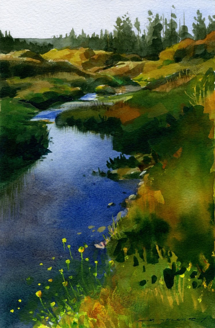
The Latah-Hangman Creek Trail Corridor project includes a nine mile trail (land and water) and targeted native plant enhancements from the bridge at Hatch Road and highway 195 downstream to the mouth of the Creek where it merges with the Spokane River. The trail project is primarily a permeable surface nature trail within a wider corridor of conservation and riparian lands associated with the Spokane Shoreline Management Program. The water trail has at least one put-in/out point. This is a new, coherent wildlife conservation and non-motorized human connectivity project to link six City of Spokane neighborhoods. It will secure natural and historic elements in a neighborhood that is the subject of increasing development
The project includes interpretive elements. Neighborhoods (Latah/Hangman Creek/Vinegar Flats), Cliff/Cannon, Browne’s Addition, Peaceful Valley, West Central, and Grandview Thorpe) have expressed an interest in educating newcomers and visitors about the history and wildlife of the area. It addresses safety concerns in the area by increasing use and using ‘safe’ environmental design elements It will provide for passive and active recreation, health and social benefits, and an understanding of the geology, biology, and history (pre and post contact) of this area.
The scope of the trail corridor has been parsed into five (V) Phases which will be addressed in geographic sequence (from the mouth of the Creek, northernmost point to south. The time sequence schedule has begun with the first two phases; the third through fifth will follow. The work is essentially upstream.
 Phase I begins at People’s Park and is a collaboration with City of Spokane. Most of the land is owned by the City, but neighborhood/community input will be solicited. This northern-most area also includes High Bridge Park which straddles open stretches of Latah Creek. There are multiple social trail linkage points, and open-space land use. It is City-owned property with a double-track right of way utility easement which can be incorporated into a trail. It has a built-up protective embankment of gabion walls.
 Phase II, further upriver, occurs in the historic community of Vinegar Flats. This area is characterized by residential and a few commercial uses with basalt bluffs across winding stretches of Creek. A rip rap armored wall of salvaged concrete separates the riparian area from the community. This section links High Bridge Park and Wentel Grant Park. Trail access could include a combination of sidewalks, sewer utility corridor and private easements. As such, Phase II will encompass a “hybrid trail” element where residential blocks abutting the Creek will have sidewalk routing when land agreements cannot be secured.
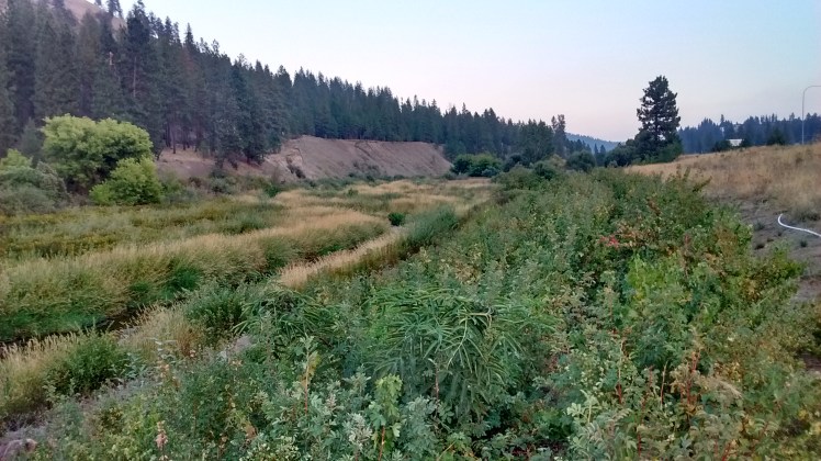
Phase III, As the Creek valley opens southward, the land-use becomes more agricultural, light industrial, and greenhouses. Parcel sizes become large with limitations imposed by lack of through roads. Across the Creek, a steep and highly erodible slope below the BNSF lines limits trail access. Public land ownership is not common in the Phase III Planning Area, therefore geographic scope has been broadened to allow more alternatives.
Phase IV This Planning Area has long natural stretches of meandering Creek, some of it in active restoration by The Land Conservancy. If trail access took the east side of the Creek it would have to stay above eroding bluffs. If the trail stayed on the west side of the Creek, users would have at least three pinch points with SR 195. Reaching south, the Spokane City owned Qualchan Golf Course, which straddles the Creek represents an opportunity for shared recreation with its numerous pedestrian bridges and paths. Above the Golf Course are Bluff Trails through public lands offering potential linkages with High Drive to the east. These Bluff trails and this landscape is under stewardship by Friends of the Bluffs, and offers views of the creek and the small agricultural uses of the adjacent land.
Phase V This southern-most Phase balances one residential area (Bridal Woods) immediately south of the Golf Course where the Creek nearly circumscribes the subdivision with another residential area and access to High Drive Park via a path. Other Bluff trails tie-into the southern end of the Golf Course (noted with red lines on attached maps). On the west side of the Creek is the Hangman Park Conservation parcel. The landscape is natural between the two residential developments. See the attached maps for the overall scope. The completed project will offer a 9 mile contiguous trail with hybrid trail elements.

 Outcomes
The outcomes of the project can be divided into the tangible trail and trail-related infrastructure, and the community network based on developing and this project.
This network will provide the core leadership and stewardship in the maintenance of the trail and plantings along the corridor.
Trail Infrastructure
A natural-surface trail with a 2’-3’ wide trail tread within a 20’ wide corridor will be typical along the Latah/Hangman Creek. This new inviting, leisure and recreational opportunity will link People’s Park near the confluence with the Spokane River, the Fish Lake Trail via High Bridge Park, the Overlook Park of Brown’s Addition, Wentel Grant Park of Vinegar Flats, and Qualchan Golf Course. Materials decisions will rely on a “light on the land” approach using hand tools as appropriate.
Interpretive signs based on research with historians and naturalists from the area including Spokane Tribal members, proximity to native tribal sites (protected), and other cultural history such as the old vinegar plant. A site and research inventory has been created.
Native plantings will improve the conservation aspects of the creek corridor in terms of erosion and wildlife/fish habitat.
Exceptional views of basaltic geology of Eastern Washington and evidence of the Ice Age Floods will be an essential aspect of the corridor.
The water trail will have at least one put-in/out spot, which is being coordinated with area water recreationists.
Social and civic infrastructure
Planning with adjacent land owners, users, and relevant agencies which increase understanding of perspectives, hopes, concerns, and potential uses.
A Community stewardship plan of the trail corridor will be fostered through the planning process. Six neighborhoods have shown interest in supporting the project and are able, through their city neighborhood councils to organize stewardship efforts. This can be used in conjunction with the Spokane Parks Department force account labor will be the maintenance tool for the trail is proposed. Already the Spokane Preservation Advocates have organized one ‘Do It’ day in conjunction with the Spokane River Clean Up.
In identifying funding sources, volunteer, professional, and administrative support, the
Latah/Hangman Creek Trail Advocates have met with City and County staff and City of Spokane elected officials to present and get feedback about conceptual plans and permit requirements.
Latah/Hangman Creek Trail Advocates have presented their conceptual plans and design guidelines to each of six Neighborhood Councils within the Trail Planning area and received enthusiastic encouragement.
The Spokane Tribe of Indians has been briefed on the project ideas and their involvement has been sought (and used) during the first year of conceptualizing plans. Trail advocates have secured funding for planning consulting work with Daniel Collins – Nicoterra Trails to take the plans in Phase I and II to a pre-design phase. Property owners within the planning area have been (and will continue to be) consulted on the plans in Phase I and II and our group is actively working with property owners who wish to contribute property or property access.
Research and prepare land agreement documents, and a protocol to be used with Spokane County Assessors Office to facilitate further trail access
.
Support
The Advocates have been working for more than a year, beginning with including this project in the adopted 2014 Spokane Regional Trail Plan. Since that time the advocates have met with individuals and groups to create a project that is community-based. The following are groups who are engaged, and how they are working with the advocates.
The Spokane Neighborhood Alliance and
Inland Northwest Trails and Conservation Coalition (INTC) have each committed $2,000 and volunteers.
Kop Construction has paid for a demonstration trail and will support historical research and donate easements as well as funding.
The City of Spokane has a small budget for work in People’s Park.
Spokane Preservation Advocates have awarded a $1500 research grant for research on interpretive signs.
The National Parks Service has awarded an annual Technical Support staff grant.
The Lands Council is hosted a Spokane River clean up that was an opportunity to showcase the project. The Lands Council has also been planting along the bank, and has been the lead in reintroducing beaver to the creek.
The Spokane Tribe of Indians are especially interested in returning native fish to the creek and are working with several groups involved with this project to accomplish this.
The Center for Justice’s Riverkeeper has donated staff time.
The Spokane River Forum is providing expertise regarding recreational facilities for water trail put in/take out points.
SNAP-Spokane has committed outreach services to homeless individuals and groups in the area.
The Spokane Regional Health District will collaborate in health improvement related efforts.
Also supportive of the program, but not financially committed:
Artists and Writers
Ice Age Flood Institute
Spokane County Parks
Spokane Tribe of Indians –
archeology, history, interpretive signage
Local developers and property owners
Faculty – Eastern Washington University
Economic, Health and Transportation Considerations
The Trail will create a leisure/recreational opportunity available through multiple public access points. It will also help retain the rural, natural and built characteristics of the landscape. Because of the narrow trail corridor, the hybrid concept, and smaller neighborhoods through which the trail will traverse, the Trail will likely have strongest value to the residents of Vinegar Flats which lacks any trail system, yet straddles the beautiful Latah Creek as it reaches for the confluence of the Spokane River below the Falls. Trail development will further increase value of other public lands not currently accessible yet along this Creek. Additional values to the Trail Corridor include wildlife viewing, and passive recreation.
The walk score of this area is 2-5, meaning almost every errand needs a car. The bike score is 31, and we anticipate this connection will allow for two improvements. (https://www.walkscore.com/score/1702-w-27th-ave-spokane-wa-99224) Increased bicycling and walking options and education about both. It will also make the area more attractive to mixed use small development (currently being investigated by land owners), which will increase retail and errand-destination options.
Additionally, the initial phases of this project fall into an area with an extremely low income. By providing connections to other areas it makes the area more attractive for development, which is beginning to happen, and allows for non-automobile access to jobs and recreation. While the adjacent neighborhoods will gain non-motorized access via their trails to+. this community trail the principal users will most likely originate from Vinegar Flats within a half mile radius. This is especially true as the development in the area is small residences, which will only be desirable with attractive outdoor amenities such as this trail
The principal user group will be pedestrians commuting or following their “routine”. Other user groups include hikers exploring the historic, ecological, and cultural elements, birders (20 types including raptors and rare swifts) artists, fitness users, cross country runners and more.
Organizers
Chris Kopczynski Chris@kopconstruction.com
Lunell Haught Lunellh@aol.com
Paul Kropp PKropp@fastmail.fm
Dan Schaffer Traildan@comcast.net